Maryland is a state located in the Mid-Atlantic region of the United States, bordering Virginia, West Virginia, and Washington, D.C. to its south and west; Pennsylvania to its north; and Delaware to its east.
ABBREVIATION: MD
NICKNAME: The Old Line State
POPULATION: 5,928,814 (2013 est.)
CAPITAL: Annapolis
STATE BIRD: Baltimore Oriole
STATE FLOWER: Black-Eyed Susan
AREA: 12,407 sq. mi.
TIME ZONE: Eastern
ENTERED UNION: Apr. 28, 1788
ALTITUDE: High, 3,360 ft. Hoye-Crest
CLIMATE: Hot summers, cool winters in south and east; warm summers, cold winters in west. Ample rainfall.
State Flag
State Seal
With Chesapeake Bay penetrating it deeply, the colony of Maryland already had a natural division when in 1767 man created an artificial division that was to affect its history. This was the Mason-Dixon line. Originally drawn to establish the boundary between lands granted to Lord Baltimore of Maryland and William Penn of Pennsylvania, the east-west line in time became the traditional dividing line between North and South. Though the state lies completely south of the line, Maryland’s population suffered from divided loyalties during the Civil War, and even today vestiges of regional differences persist.
Chesapeake Bay, providing Maryland with an extensive fishing ground, once produced more oysters than any other region in the U.S.; it also contributes to the mild, humid climate which make rich tobacco and truck crops, along with a valuable dairy industry possible. On a northwest inlet of the bay is Baltimore, once the third largest port in the nation (currently 17th busiest) and a major manufacturing center due to the steel industry. Baltimore once had the world’s largest steel plant (accounting for 80% of the states manufacturing production). Sadly, steel production in America has been drastically reduced towards the end of the last century, while steel production has increased in the developing countries such as China, Brazil, and India.
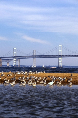
The Chesapeake Bay Bridge, Maryland
After long arguments over the location of the national capital, Congress in 1790 accepted a joint offer of land from Maryland and Virginia. President Georg Washington himself chose a site 10 miles square on which to build a “Federal City”. During the first decades it appeared that not all of the land would be required for federal offices, accordingly, the portion given by Virginia was returned to the state in 1846. The present District of Columbia comprises about 70 square miles, all of it ceded by Maryland.
FUN FACTS:
The Maryland State House in Annapolis is the oldest state capitol still in continuous use for meetings of the state legislature.
The first successful passenger balloon flight in the U.S. took place in Baltimore on June 24, 1784. The only person onboard was 13-year-old Edward Warren.
In 1860 Baltimore had more free African Americans than any other major U.S. city. The Chesapeake Marine Railway and Dry Dock Company, founded in 1869, was operated by African Americans. Today, Prince George’s Country is one of the wealthiest predominantly black communities in the country.
Annapolis, Maryland is home to the United States Naval Academy founded on October 10, 1845.
The first school in the United States was opened in 1696 and named King Williams School.
The Chesapeake Bay divides Maryland into two sections the Eastern Shore and the Western Shore.